![Can You Go 10 Years Back on Google Earth? [Find Out]](https://gearthhacks.com/wp-content/uploads/2023/01/Capture-e1673367516833.png)
![Can You Go 10 Years Back on Google Earth? [Find Out]](https://gearthhacks.com/wp-content/uploads/2023/01/Capture-e1673367516833.png.webp)
Google Earth is a powerful tool that allows users to explore and visualize the world in new ways. With its high-resolution satellite and aerial imagery, users can zoom in and see incredible detail of any location on the planet.
But have you ever wondered if it’s possible to go back in time and view how a particular location looked in the past? Can you go back 10 years on Google Earth and see what has changed? It’s possible to go back in time on Google Earth to view historical satellite images.
In this blog post, we’ll explore the historical imagery feature in Google Earth and see if it’s possible to view older versions of satellite and aerial imagery.
What Is Google Earth?

Google Earth is a virtual globe, map, and geographical information program that was originally called EarthViewer 3D. It was created by Keyhole, Inc, a company that was acquired by Google in 2004.
With Google Earth, users can explore the world and see satellite images, maps, terrain, 3D buildings, and other geographic information. They can also view layers such as roads, borders, and placemarks, and search for specific locations or points of interest.
Google Earth is available on desktop computers, mobile devices, and as a web application. It can be used for a variety of purposes, including education, exploration, travel planning, and more.
One of the most popular features of Google Earth is the ability to “fly” to different locations and view them in 3D. This allows users to get a sense of the layout and terrain of a place, as well as see landmarks and other points of interest.
In addition to the standard version of Google Earth, there’s also a pro version available for purchase that includes additional features and tools for business and professional use.
Overall, Google Earth is a powerful and user-friendly tool that allows users to explore and discover the world around them in a unique and interactive way.
Time Slider
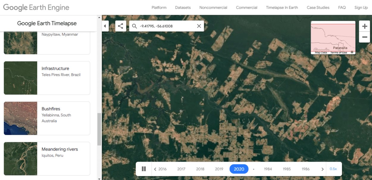
The Time Slider feature on Google Earth is a tool that allows users to see how a location has changed over time. This is achieved by displaying a series of satellite images of the same location from different points in time.
To use the Time Slider, users simply need to enable it in the Google Earth settings and then navigate to the desired location. As they move the Time Slider bar, they will see the satellite imagery update to reflect the selected time period.
One of the main benefits of the Time Slider is that it allows users to see how a location has changed over the years. This can be interesting for a variety of reasons, such as seeing the growth of a city or the effects of natural disasters.
In addition to viewing satellite imagery, the Time Slider also displays information about the availability of imagery for a particular location and time period. This can help users understand the limitations of the Time Slider and why certain images may not be available.
Overall, the Time Slider is a useful and engaging feature of Google Earth that allows users to explore the past and see how locations have changed over time.
Imagery Dates
The availability of imagery on Google Earth varies depending on the location and time period. In some cases, users may be able to view satellite images that date back several decades, while in other cases, the most recent imagery may only be a few months or years old.
There are several factors that determine the availability of imagery on Google Earth, including the frequency of satellite imagery collection, the age of the satellite, and the resolution of the images.
For example, some satellites may collect imagery more frequently than others, and some images may have higher resolution than others.
| Location | Available Imagery |
| New York City | Imagery from 2007-present |
| London | Imagery from 2009-present |
| Sydney | Imagery from 2016-present |
Users can view the imagery dates for a particular location on Google Earth by using the Time Slider feature and looking at the information displayed at the bottom of the screen. This will show the range of available imagery for that location, as well as the specific date of the image currently being displayed.
It’s important to note that the availability of imagery on Google Earth is constantly changing as new images are added and older images are updated. This means that users may be able to see more or less of a location’s history depending on when they access Google Earth.
Overall, the imagery dates on Google Earth can give users a sense of the history and evolution of a location, but it’s important to understand the limitations and factors that determine the availability of imagery.
Historical Imagery


Google Earth includes a feature called Historical Imagery that allows users to access and view satellite images of a location from different points in time. This can be a useful tool for exploring the history and evolution of a place, as well as for researching specific events or changes that have occurred over the years.
To access Historical Imagery on Google Earth, users can use the Time Slider feature and navigate to the desired location and time period. Alternatively, users can also use the “Go to Date” function to select a specific date and view the available imagery from that time.
It’s important to note that the availability of Historical Imagery on Google Earth can vary depending on the location and time period. In some cases, there may be a limited amount of imagery available, or the images may be of lower resolution.
Despite these limitations, Historical Imagery can still be a valuable resource for exploring the past and seeing how a location has changed over time. Whether for research, curiosity, or just plain fun, it’s a unique and interesting feature of Google Earth that can provide a new perspective on the world around us.
Limitations
One limitation is that Google Earth can only display satellite imagery that has been captured by satellite at a certain point in time. This means that it’s not possible to use Google Earth to view what an area looked like in the past.
While Google Earth does have a “historical imagery” feature, this only allows users to view imagery from previous points in time for a limited number of locations and only goes back as far as the satellite imagery available for that location.
Another limitation to consider is that Google Earth isn’t able to display real-time information. It can only show satellite imagery as it existed at a certain point in time, so it’s not possible to use Google Earth to see what an area looks like at the present moment.
It’s important to keep these limitations in mind when using Google Earth and to understand that it’s a tool for viewing satellite imagery from the past, rather than a way to view real-time or historical footage of an area.
FAQs
Can I View Satellite Imagery From 10 Years ago on Google Earth?
Unfortunately, it’s not possible to view satellite imagery from exactly 10 years ago on Google Earth.
The “historical imagery” feature on Google Earth allows users to view satellite imagery from previous points in time, but the available imagery varies by location and may not go back as far as 10 years.
How Far Back Can I View Satellite Imagery on Google Earth?
The available satellite imagery on Google Earth varies by location and the “historical imagery” feature may not be available for all areas.
In some cases, it may be possible to view imagery that is several years old, but it’s not possible to view satellite imagery from an arbitrary date in the past.
Is Google Earth Able to Display Real-time Imagery?
No, Google Earth isn’t able to display real-time imagery.
It can only display satellite imagery as it existed at a certain point in time.
Conclusion
- In conclusion, it’s possible to go back in time on Google Earth to view historical satellite images.
- The available imagery is limited and may not go back as far as 10 years for all locations.
- To access Historical Imagery on Google Earth, users can use the Time Slider feature and navigate to the desired location and time period.
- The resolution and clarity of the older images may not be as high as the current images.
- It’s worth noting that Google Earth is constantly updating and adding new imagery, so it’s worth checking back periodically to see if older images have become available.
Related Articles
- How Do I Open Google Earth? (Easy Way)
- Is There an Offline Version of Google Earth? (Must Know)
- Can You Change the Year on Google Earth?[Find Out]