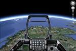
Country: !Various

  • F-16 cockpit

    F-16 cockpit

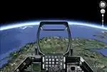
    Go to C:Program filesGoogleGoogle Earthclient esflightsimhud, and replace “generic.ini”

  • F-16 HUD

    Go to C:Program filesGoogleGoogle Earthclient esflightsimhud, and replace "generic.ini"

  • VortexMaps

    VortexMaps

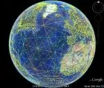
    http://www.vortexmaps.com/hagens-grid-google.php In the upper left corner of the Google Earth screen, click File. Then click Open. You will be able to browse to where you…

  • Zambezi River and Victoria Falls tour

    Zambezi River and Victoria Falls tour

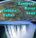
    The Zambezi river is the fourth-longest river in Africa, and the largest flowing into the Indian Ocean from Africa. The 3540 km (2200 mile) long…

  • Nuclear Sites

    Nuclear Sites

    This collection contains the locations of various sites throughout the world having something to do with nuclear power or nuclear weapons. These original data originated…

  • Mount Everest tour

    Mount Everest tour

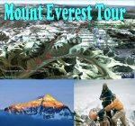
    Mount Everest. The World’s highest mountain, tallest peak. Also called Sagarmatha (Nepal, meaning “Head of the Sky”), Chomolungma (Tibet, meaning “Goddess Mother of the World”),…

  • K1, K2, K3, K4, K5 mountains

    K1, K2, K3, K4, K5 mountains

    Beyond the famous K2 check out the sisters K1, K3, K4 and K5. Thomas Montgomerie was the member of the team who designated it “K2”…

  • more than 1000 mountain huts in the alps

    more than 1000 mountain huts in the alps

    In this file you see the location of all important mountain huts in the alpine region (italy, france, austria, switzerland, germany) and some huts outside…

  • World of waterfalls

    World of waterfalls

    Site with waterfalls worldwide. To have them showing up in GE click on View larger map. Then they show up in GM but you’ll also…

  • Red, Orange, Yellow Border Lines

    Red, Orange, Yellow Border Lines

    Usually border lines on GE are marked by yellow lines. Throughout the globe there are several examples of red border lines. Here is an example…

  • 800 Satellites Tracked in Google Earth

    800 Satellites Tracked in Google Earth

    Some amateur radio enthusiasts started out by creating an extensive Google Earth network link which showed the current positions of amateur radio satellites. Next they…

  • Ancient Pyramids Worldwide

    Ancient Pyramids Worldwide

    This is a really neat collection of pyramids worldwide. This folder contains 38 pyramids from places like South America, Mexico and Egypt. I chose not…

  • Global Infrared Satellite Images

    Global Infrared Satellite Images

    Global Infrared Satellite Images

  • Seven Years War (map overlays)

    Seven Years War (map overlays)

    The Seven Years’ War (1754 and 1756–1763) pitted Great Britain, Prussia, and Hanover against France, Austria, Russia, Sweden, and Saxony. Spain and Portugal were later…

  • Pangaea

    Pangaea

    Pangaea (Greek for “all lands”) is the supercontinent that existed during the Paleozoic and Mesozoic eras, before the process of plate tectonics separated the component…

  • Football stadiums around the world

    Football stadiums around the world

    A list of stadiums, mainly geared towards football – the european version of the game, called “soccer” on the other side of the atlantic -,…