![What Are Cool Things on Google Earth? [Must Know]](https://gearthhacks.com/wp-content/uploads/2022/12/google_earth_banner-1.jpg)
![What Are Cool Things on Google Earth? [Must Know]](https://gearthhacks.com/wp-content/uploads/2022/12/google_earth_banner-1.jpg.webp)
Hey everyone! I hope you’re doing great today. I’m super excited to share with you some of the amazing features and sights you can find on Google Earth. This platform has revolutionized the way we view and explore our planet and it’s truly a treasure trove of cool and fascinating things.
From breathtaking aerial views of our favorite cities to exploring far-off, exotic locations, Google Earth is a tool that has something to offer everyone. I’ve spent countless hours exploring here and I can’t wait to share with you some of the truly awe-inspiring things I’ve discovered.
One of the main features of Google Earth is the ability to view satellite imagery of the Earth’s surface. This allows users to zoom in and out to view different locations in great detail, from major cities to remote wilderness areas.
Overall, the purpose of this blog post is to highlight some of the cool things you can do on Google Earth and to provide tips and resources for getting the most out of this powerful tool. Continue reading to get detailed information.
Features of Google Earth
| Feature | Description |
| Historical Imagery | Allows users to view past imagery of a location and see how it has changed over time. Includes time-lapse feature to see changes over several years. |
| Street View | Provides panoramic street-level views of locations, allowing users to virtually explore a location as if they were physically there. Includes the ability to walk down streets and explore buildings in 3D. |
| 3D Buildings | Allows users to view buildings in 3D, providing a more detailed and realistic view of a location. Includes the ability to rotate and explore the building in 3D. |
Historical Imagery
One of the most interesting and unique features of Google Earth is the ability to view historical imagery of the Earth’s surface. This feature allows users to travel back in time and see how different places looked in the past, providing a fascinating perspective on how the world has changed over the years.
To access historical imagery on Google Earth:
- Click on the clock icon located in the top-right corner of the screen
- From there, you can use the timeline feature to choose a specific date and see how the Earth’s surface looked on that day.
- You can also use the “time slider” feature to animate the imagery and see how a location has changed over a period of time.

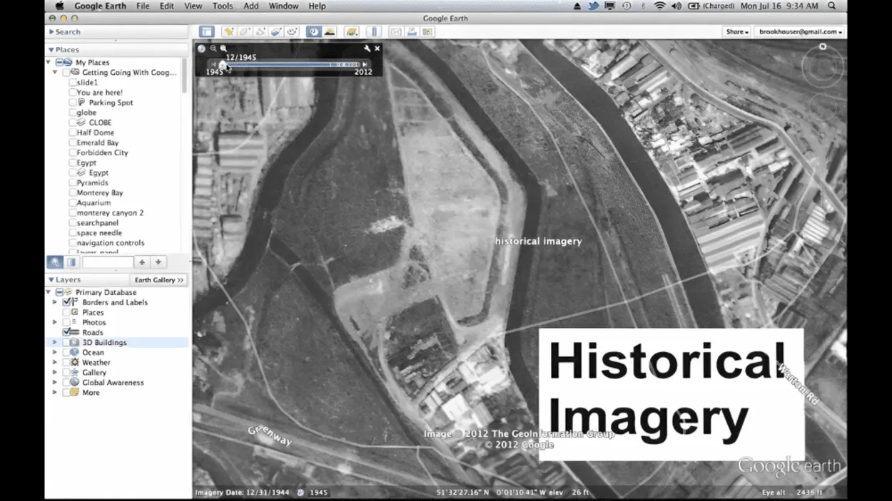
Using historical imagery can be a great way to research and learn about different locations and time periods. For example, you can use historical imagery to study the development of cities and towns or to see how different landscapes have been affected by natural disasters or human activity.
Historical imagery can also be used to explore the history of different countries and cultures, providing a unique perspective on the past.
When using historical imagery, it’s important to keep in mind that the imagery may not be available for all locations and that the quality and resolution of the imagery can vary depending on the date and location. It’s also important to note that the historical imagery is not always complete, as some areas may have been obscured by clouds or other factors.
Despite these limitations, historical imagery is an incredibly powerful tool that can provide a unique perspective on the world, and is definitely worth exploring for anyone interested in learning about the past.
Street View
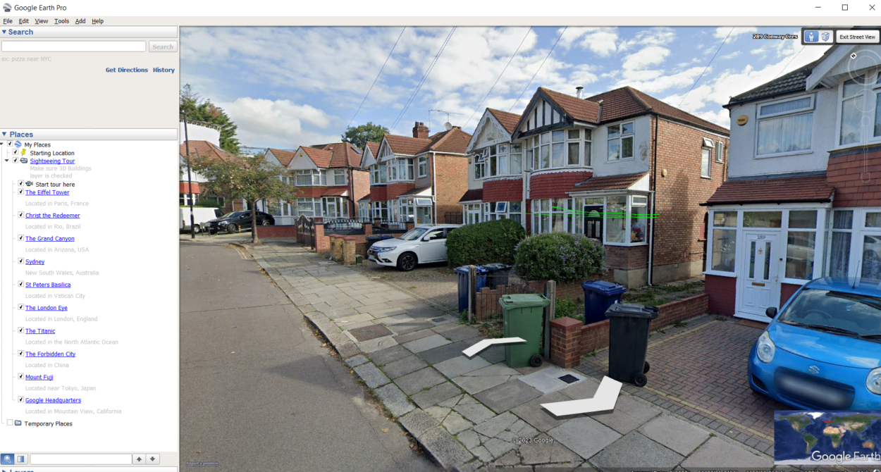

Google Earth’s street view feature allows users to virtually walk the streets of cities and towns all over the world. This feature provides a realistic and immersive experience for exploring different locations and can be a great tool for both virtual travel and planning real-life trips.
To access street view in Google Earth, simply click on the “pegman” icon located in the top-right corner of the screen and drop it on the location you want to explore. This will open a street view window, where you can use the arrow keys or click on the blue lines to navigate through the streets.
Street view can be a great way to explore different neighborhoods and landmarks, providing a sense of what it’s like to be there in person. You can also use street view to plan real-life trips, by checking out routes and getting a sense of distances and landmarks.
One of the best things about street view is that it’s constantly updated with new imagery, meaning that you can see new locations and get a sense of what’s changed in recent years. Google also allows users to submit their own street view images, so you can see places through the eyes of locals or other travelers, creating a more authentic experience.
It’s important to keep in mind that street view isn’t available for all locations and that the quality and resolution of the imagery can vary depending on the location and date of the image. Also, because street view relies on cars and other vehicles to capture the images, not all streets may have the same coverage.
Despite these limitations, street view is an incredibly powerful tool that can provide a unique perspective on the world, and is definitely worth exploring for anyone interested in virtual travel and planning real-life trips.
3D Imagery


Google Earth’s 3D buildings feature is a powerful tool that allows users to view detailed 3D models of buildings and other structures in select cities around the world. This feature provides a unique perspective on architecture and urban planning and can be a great tool for both virtual travel and research.
To access 3D buildings in Google Earth:
- Zoom in on a city or town and you’ll see the 3D buildings appear.
- You can then click on a building to view it in more detail and see information such as the building’s name and address.
One of the best things about the 3D buildings feature is that it allows users to explore different cities and towns in a way that would be impossible in real life. For example, users can fly through the canyons of skyscrapers, get a sense of the scale of large buildings, and even view the interiors of some buildings, such as museums and landmarks.
The 3D buildings feature can also be used for research and educational purposes. You can use it to study architecture, urban planning, or even historical preservation, by observing changes in the built environment over time.
It’s important to keep in mind that the 3D buildings feature isn’t available for all locations and that the quality and resolution of the models can vary depending on the location and date. Also, the 3D models are created by different sources, so some buildings may have more detailed models than others.
Despite these limitations, the 3D buildings feature is an incredibly powerful tool that can provide a unique perspective on the world, and is definitely worth exploring for anyone interested in architecture, urban planning, and virtual travel.
Ocean Exploration
Google Earth’s ocean exploration feature is a unique tool that allows users to explore the depths of the ocean and discover the diverse marine life that lives there. This feature provides a fascinating look into the underwater world and can be a great tool for both virtual travel and education.
To access the ocean exploration feature in Google Earth:
- Zoom out to view the ocean
- Click on the “ocean” layer located in the top-right corner of the screen
- This will show an overlay of the ocean floor, complete with detailed bathymetry and information on ocean currents and temperatures
- You can also explore the ocean floor in 3D by clicking on the “3D” button, which will allow you to fly through the ocean and see the various underwater features
One of the best things about the ocean exploration feature is the ability to discover hidden gems of the ocean, such as shipwrecks, underwater mountains, and marine life. Users can also learn about the oceanic habitats and the creatures that live there, including information about their biology, behavior, and conservation status.
This feature can also be used for educational and research purposes, as it allows students and researchers to explore the ocean in a way that would be impossible in real life. It can be used to study oceanography, marine biology, and environmental science, providing a window into the mysterious and vast underwater world.
FAQs
How Accurate Is the Information on Google Earth?
The information in Google Earth is based on available data and can vary in accuracy depending on the location and date.
Some areas may not have recent data or the same level of detail as others.
How Often Is Google Earth Updated?
Google Earth updates its data periodically.
But the frequency of updates can vary depending on the location and data source.
Can I Use Google Earth for Commercial Purposes?
Yes, Google Earth can be used for commercial purposes.
But you’ll need to obtain a commercial use license from Google.
Does Google Earth Have all the Locations in the World?
Google Earth has a large amount of data for locations around the world.
But it may not have information for all locations.
Conclusion
- Google Earth is a powerful tool that allows users to explore the world in a whole new way.
- From historical imagery to street view and 3D buildings to ocean exploration, the possibilities are endless.
- It’s a great tool for virtual travel, research, and education, and can provide a unique perspective on the world that would be impossible to get otherwise.
- Google Earth’s ocean exploration feature provides a fascinating look into the underwater world and can be a great tool for both virtual travel and education.
- Whether you’re interested in architecture, urban planning, marine life, or just want to explore the world from the comfort of your own home, Google Earth is definitely worth checking out.
Related Articles
- How Do I Change The Year On Google Earth On My IPAD? (Find out)
- Why Would a House Be Blurred Out on Google Earth? (Must Know)
- What is the Difference Between Google Earth Pro and Free? (Must Know)