![When Did Google Earth Come Out? [The Truth]](https://gearthhacks.com/wp-content/uploads/2022/12/Google-Earth-GeologyPage_1250x-1.jpg)
![When Did Google Earth Come Out? [The Truth]](https://gearthhacks.com/wp-content/uploads/2022/12/Google-Earth-GeologyPage_1250x-1.jpg.webp)
Google Earth is a virtual mapping tool that has revolutionized the way we explore the world from the comfort of our own homes. Developed by Google, it allows users to view satellite images of the earth, 3D models of buildings, and other geographical features.
Google Earth came over 15 years ago. It has come a long way since its launch. From its early days as a simple virtual mapping tool to its current status as a cutting-edge technology platform, the evolution of Google Earth has been nothing short of amazing.
In this blog post, we’ll delve into the history of Google Earth, its purpose, and the impact it has had on the world since its launch.
The purpose of this post is to shed light on the evolution of Google Earth, from its earliest days as a concept to the widely used tool it is today. It’ll provide an in-depth look at the key features and innovations that have made Google Earth the go-to platform for virtual mapping.
The thesis statement of this post is that Google Earth has made a significant impact on the way we interact with the world, and its evolution continues to shape the future of virtual mapping.
What Is Google Earth?
Google Earth is a virtual mapping tool that provides users with a comprehensive and interactive view of the earth from space. It allows users to explore satellite images, 3D models of buildings, and other geographical features, providing a unique perspective on our planet.
The key features of Google Earth include the ability to view the earth from different angles and perspectives, including street view and satellite view.
It also provides a wealth of information about various locations, including geographical information, historical data, and cultural landmarks. Additionally, Google Earth offers a range of tools and features that allow users to create and share their own custom maps and locations.
Google Earth differs from Google Maps in several key ways. While both platforms provide satellite imagery and mapping information, Google Earth offers a more immersive and interactive experience, allowing users to explore the earth in 3D and even travel to different parts of the world virtually.
Additionally, Google Earth provides a greater level of detail and accuracy, with higher-resolution imagery and more comprehensive data on various locations.
Whether you’re exploring your own neighborhood or traveling to remote parts of the world, Google Earth provides an unprecedented level of detail and information, making it a valuable tool for anyone looking to better understand our planet.
The Early Days of Google Earth

Ah, the early days of Google Earth! It’s hard to believe that it’s been over 15 years since the launch of this game-changing virtual mapping tool. But let’s rewind a bit, back to the early days when Google Earth was just a twinkle in the eyes of its founders.
It all started with a passion for exploring the world, a love of technology, and a desire to bring the two together. The concept for Google Earth was born from a collaboration between several entrepreneurs, who saw the potential for using satellite imagery and mapping technology to create an immersive and interactive virtual world.
The road to launch was not without its challenges, however. The team faced numerous obstacles, including the limitations of technology at the time, the sheer size and complexity of the task, and the challenge of obtaining high-resolution imagery for large parts of the world.
Despite these challenges, the team persevered, driven by their passion for the project and their belief in its potential. Through a combination of innovation, hard work, and collaboration with key partners, they were able to bring their vision to life and launch the first version of Google Earth.
The early days of Google Earth may have been filled with challenges, but they were also a testament to the power of passion and perseverance. It’s truly inspiring to look back and see how far the platform has come since its humble beginnings, and it’s exciting to think about what the future holds for this innovative tool.
From the dedicated team who brought it to life, to the countless users who have explored and discovered new parts of the world through its lens, the story of Google Earth is a testament to the power of human creativity and the possibilities of technology.
The Launch of Google Earth

It was a day that would go down in history. After years of hard work and dedication, the team behind Google Earth was finally ready to launch their groundbreaking virtual mapping tool to the world. The anticipation was palpable, and excitement was in the air as the countdown to launch began.
And then, with a flourish, Google Earth was officially launched! The response was overwhelming, with people all over the world eager to explore this new and innovative tool. From the very first moments of its launch, it was clear that Google Earth was something special – a tool that would change the way we viewed and interacted with the world forever.
For those who were there on launch day, it was a truly magical experience. From the thrill of exploring new parts of the world to the excitement of discovering hidden treasures and hidden gems, Google Earth provided an experience like no other.
It was a tool that truly opened up the world, giving users a unique and interactive perspective on the planet we call home.
And of course, let’s not forget the media frenzy that followed the launch of Google Earth. News outlets from all over the world clamored to report on this revolutionary new tool, and the buzz and excitement around Google Earth only continued to grow.
The launch of Google Earth was a momentous occasion, a turning point in the history of virtual mapping, and a true testament to the power of human creativity and innovation. From its launch day to the present day, Google Earth continues to inspire and amaze, providing users with a truly unique and incredible way to explore and discover the world.
Evolution of Google Earth
| Year | Event |
| 2001 | Google Earth is first developed as Keyhole Inc. |
| 2004 | Keyhole Inc. is acquired by Google |
| 2005 | Google Earth is publicly released |
| 2009 | Google Earth 5.0 is released with improved 3D imaging and additional features |
| 2013 | Google Earth Pro is released, offering advanced features for businesses and researchers |
| 2015 | Google Earth for mobile devices is released |
| 2018 | Google Earth receives major updates, including a new Voyager feature and updated imagery |
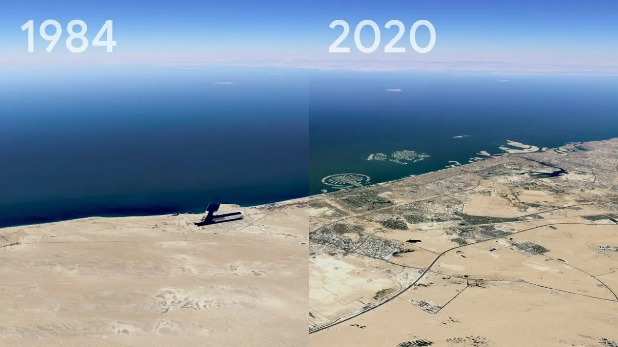
It’s amazing to think about how far Google Earth has come since its launch over 15 years ago. From its early days as a simple virtual mapping tool to its current status as a cutting-edge technology platform, the evolution of Google Earth has been nothing short of remarkable.
In the years following its launch, Google Earth continued to evolve and expand, adding new features, tools, and capabilities that further enhanced the user experience. One of the biggest additions was the introduction of Street View, which allowed users to explore the world’s streets and landmarks in a whole new way.
Another key development in the evolution of Google Earth was the incorporation of more data and information, including real-time traffic updates, information on local businesses and points of interest, and even 3D models of buildings and landmarks.
Another major step forward came with the introduction of Google Earth Pro, a professional version of the tool that offered even more advanced features and capabilities. This version was designed specifically for businesses, researchers, and other organizations, and provided them with powerful tools and data to help them better understand the world and make informed decisions.
In recent years, Google Earth has continued to push the boundaries of what is possible, incorporating new technologies like virtual reality and artificial intelligence to create an even more immersive and interactive experience.
With new capabilities being added all the time, it’s clear that the evolution of Google Earth is far from over, and that this innovative tool will continue to evolve and change the world for years to come.
Here’s a list of some of the features that have been added to Google Earth over time:
- Street View allows users to explore street-level images of locations all over the world.
- Local Business and Point of Interest information provides users with information about local businesses, points of interest, and other useful data.
- 3D Buildings provides users with 3D models of buildings and other structures, allowing them to explore and experience these structures in a whole new way.
- Real-Time Traffic Updates provides users with real-time traffic updates, helping them to avoid congestion and make better travel plans.
FAQs
What Is Google Earth?
Google Earth is a virtual mapping tool that provides users with a 3D representation of the world, allowing them to explore and discover:
- New places
- Landmarks
- Other points of interest
Is Google Earth Free to Use?
Yes, Google Earth is free to use for personal use.
However, there’s also a professional version called Google Earth Pro that is designed for businesses, researchers, and other organizations, and is available for a fee.
What Are the System Requirements for Google Earth?
Google Earth requires a Windows or Mac computer with at least 1 GB of RAM and a 3D graphics card.
You’ll also need an internet connection to use many of the features and capabilities of Google Earth.
What Can I Do With Google Earth?
With Google Earth, you can explore the world in a whole new way, discovering new places, landmarks, and other points of interest.
You can also use Google Earth to plan trips, make informed decisions, and research different locations and features.
Final Thoughts
- In conclusion, Google Earth has come a long way since its launch over 15 years ago.
- From its early days as a simple virtual mapping tool to its current status as a cutting-edge technology platform, the evolution of Google Earth has been nothing short of amazing.
- With new features and capabilities being added all the time, it’s clear that this innovative tool is far from reaching its full potential.
- Whether you’re a business looking to make informed decisions, a researcher looking to better understand the world, or simply someone who loves to explore and discover new things, Google Earth is the tool for you.
- So why not give it a try today? Whether you’re a seasoned veteran or a first-time user, the world is waiting for you to discover it.
Related Articles
- How Do You Change the Time in Google Earth 2023? [Answered]
- How Do I See Different Years in Google Earth on iPhone? [Find Out]
- How Do You Go Back in Time on Google Earth?[Guide]