![When Was the Last Time Google Earth Was Updated in My Area? [Revealed]](https://gearthhacks.com/wp-content/uploads/2022/12/google_earth_banner-1.jpg)
![When Was the Last Time Google Earth Was Updated in My Area? [Revealed]](https://gearthhacks.com/wp-content/uploads/2022/12/google_earth_banner-1.jpg.webp)
Are you curious to know when the most recent update to Google Earth in your area occurred? If so, you’re not alone. Many people have questions about the timing of updates to Google Earth and how they impact their local area.
In this blog post, we’ll explore what to consider when trying to determine when the last time Google Earth was updated in your area, as well as how to get the most out of the program.
So if you’re eager to find out when Google Earth was last updated in your area, read on!
How to Check When Google Earth Was Last Updated in Your Area?
If you are curious to know when Google Earth was last updated in your area, then you’ve come to the right place! Google Earth is a powerful tool used to view satellite images of various locations around the world.
This can be useful for identifying landmarks, exploring new places, and viewing detailed images of an area. With the help of Google Earth, it’s now possible to easily check when Google Earth was last updated in your area.
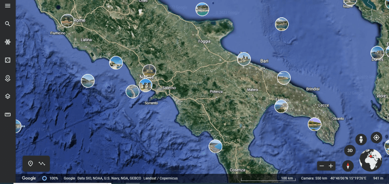
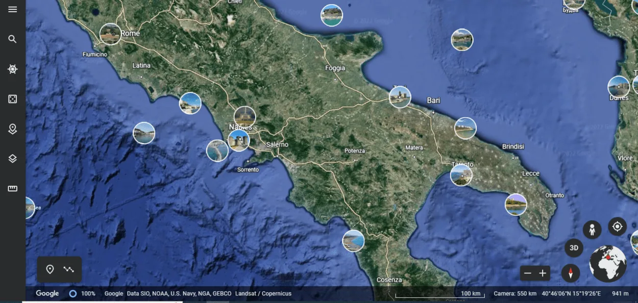
To get started, launch Google Earth on your device. Once launched, search for the location that you are interested in. The map will then load with a layer of satellite imagery at the top. Click on the three-bar icon located in the top left corner of the screen.
This will open a panel of options. Select “Historical Imagery” from the list. A timeline will appear at the bottom of the screen, displaying when each version of the satellite imagery was taken.
You can use the timeline to identify when Google Earth was last updated in your area. All you have to do is scroll through the list and look for the date of the most recent image.
If you want to see a detailed image of the area, simply click on the image associated with the most recent date. This will open a high-resolution image of the area, allowing you to zoom in and explore further.
What Factors Influence How Often Google Earth Is Updated in Your Area?
When it comes to how often Google Earth is updated in your area, there are a variety of factors that play into the frequency. The major ones include the type of imagery available, the availability of data, the resources of Google and its partners, and demand.
- Type of Imagery: Different types of imagery require different levels of resources for capture and processing. For example, satellite images typically require more data and processing power than aerial photographs or street-view images. Consequently, updates to satellite images may not be as frequent as updates to other types of imagery.
- Availability of Data: In some cases, the availability of data can affect the rate at which updates occur. For instance, if there’s a high volume of data available for an area, updates may happen more often as Google and its partners are able to process and integrate the data faster. On the other hand, if there is limited data available for an area, updates may take longer.
- Resources: The resources available to Google and its partners also play a part in how often updates occur. If they have enough resources and technology available, they may be able to process the data quicker and thus update the maps more frequently.
- Demand: Finally, the demand for updates in a particular area can influence how often Google Earth is updated. If there’s a high demand for updated imagery in a certain area, Google may be more inclined to provide more frequent updates as they want to satisfy customer needs.
Overall, there are several factors that come into play when it comes to how often Google Earth is updated in your area. The type of imagery available, the availability of data, the resources of Google and its partners, and the demand for updated imagery all have a role in determining how frequently maps are updated.
How to Get The Most Up-to-date View of Your Area?

If you want to get the most up-to-date view of your area on Google Earth, there are a few things you can try:
- Clear your cache and reload the application: This will cause Google Earth to check for updated imagery and may display more recent imagery if it’s available.
- Zoom in and out or pan the map: Sometimes more recent imagery is available, but it isn’t immediately visible. Zooming in or out or panning the map may cause the imagery to update.
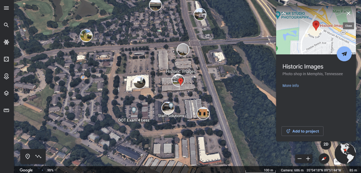
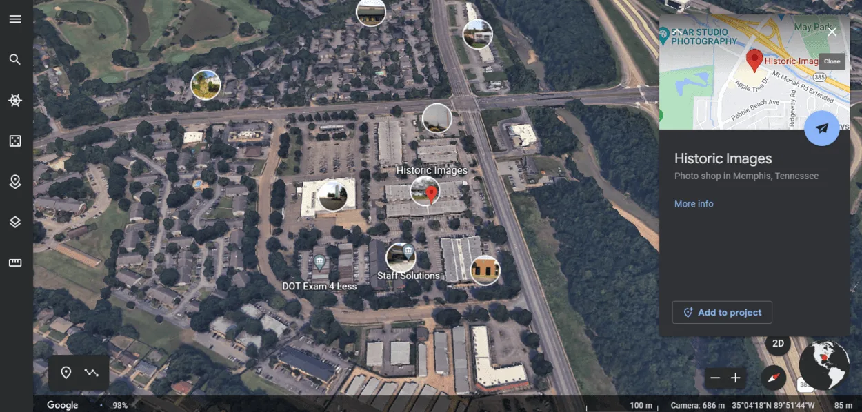
- Check the date of the most recent imagery: To see when the most recent imagery was captured, right-click on your location and select “What’s here?” The date of the most recent images will be displayed at the bottom of the information box that appears.
- Use the “Historical Imagery” feature: If you are interested in seeing how an area has changed over time, you can use the “Historical Imagery” feature in Google Earth. This feature allows you to view past versions of satellite and aerial imagery for a specific location. To access this feature, use the timeline feature located in the top right corner of the Google Earth screen.
Keep in mind that the frequency of updates can vary depending on the location, and it may not always be possible to find the most recent imagery if it’s not yet available. However, by following these tips, you can get the most up-to-date view of your area on Google Earth.
How to View the Date of the Most Recent Google Earth Imagery For Your Area
If you want to view the date of the most recent Google Earth imagery for your area, you can follow these steps:
- Open Google Earth and navigate to your location.
- Right-click on your location and select “What’s here?” from the menu.
- An information box will appear on the screen, showing details about the location you selected.
- Scroll to the bottom of the information box to see the date of the most recent imagery.
Keep in mind that the date displayed will be the date of the most recent imagery available for that location. It is possible that more recent imagery exists, but is not yet available on Google Earth.
You can try clearing your cache and reloading the application or zooming in and out or panning the map to see if more recent imagery becomes available.
How Often Is Google Earth Updated?
Google Earth is a powerful tool for viewing and exploring the world, and its imagery is constantly being updated to provide users with the most accurate and up-to-date view of the earth possible. However, the frequency of updates can vary depending on the location.
In general, more urban and frequently photographed areas are updated more frequently than less populated or remote areas. This is because there are more resources available to capture and process imagery for these areas, and there’s often a greater demand for up-to-date imagery in these areas.
It’s important to note that the frequency of updates can also be affected by factors such as weather conditions, availability of imagery sources, and technological capabilities. For example, updates may be more frequent in areas with clear, cloud-free skies, or in areas where there are multiple sources of imagery available.
Overall, Google Earth works hard to provide users with the most up-to-date imagery possible, but it’s important to understand that the frequency of updates can vary depending on a number of factors.
FAQs
How Often Is Google Earth Updated?
Google Earth updates its imagery periodically, but the frequency of updates can vary depending on the location.
In general, more urban and frequently photographed areas are updated more frequently than less populated or remote areas.
Can I See the Date of the Most Recent Google Earth Imagery for My Area?
Yes, you can see the date of the most recent imagery for any location in Google Earth by right-clicking on the location and selecting “What’s here?” from the menu.
The date of the most recent images will be displayed at the bottom of the information box that appears.
How Can I Find Out if Google Earth Has More Recent Imagery Available for My Area?
If you believe that Google Earth has more recent imagery available for your area, you can try clearing your cache and reloading the application. This will cause Google Earth to check for updated imagery and may display more recent imagery if it’s available.
Alternatively, you can try zooming in and out or panning the map to see if more recent imagery is displayed. If you are still unable to see more recent imagery after trying these steps, it’s possible that no more recent imagery is currently available for your area.
Conclusion
- In conclusion, Google Earth is a valuable tool for viewing and exploring the world, and its imagery is constantly being updated to provide users with the most accurate and up-to-date view of the earth possible.
- The frequency of updates can vary depending on the location, with more urban and frequently photographed areas typically being updated more frequently than less populated or remote areas.
- If you are interested in seeing the most recent imagery available for a specific location, you can use the “What’s here?” feature in Google Earth to view the date of the most recent imagery.
- You can also use the “Historical Imagery” feature to view past versions of satellite and aerial imagery for a specific location.
- By understanding how Google Earth updates its imagery and how to access the most recent imagery available, you can get the most out of this powerful tool and gain a better understanding of the world around you.
Related Articles
- Is Google Earth Free? [Revealed!]
- Can I See My House on Google Earth? (Find Out!)
- How to Use Google Earth in Chrome? [Find Out]