Welcome to the United States of America, where every state, city, and landmark tells a unique story. And what better way to navigate this sprawling mosaic of culture and geography than with the trusty companion of an American map?
In this journey through cartography, we embark on a quest to unravel the secrets of the American map. Beyond its mere function as a tool for navigation, the American map serves as a window into the soul of a nation, revealing the rich tapestry of its history, heritage, and aspirations.
So, join us as we embark on an adventure across the heartland of America, guided by the lines, colors, and contours of the American map.
Whether you’re a seasoned traveler or an armchair explorer, prepare to be captivated by the boundless wonders that await us on this map-filled odyssey through the land of the free and the home of the brave.
Geography of USA
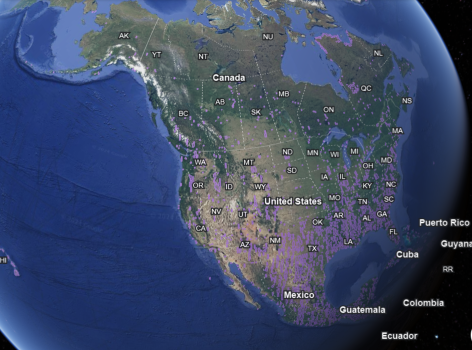

The geography of the United States is incredibly diverse, encompassing a wide range of landscapes, climates, and natural features across its 50 states and various territories. Here’s an overview of the geography of the USA:
Regions:
The USA can be broadly divided into several regions, each with its unique geography:
- Northeast: Known for its historic cities, rolling hills, and coastal plains along the Atlantic Ocean.
- Midwest: Characterized by vast plains, fertile farmland, and the Great Lakes, the largest group of freshwater lakes in the world.
- South: Home to the Appalachian Mountains, the Mississippi River, and diverse ecosystems ranging from swamps and bayous to beaches and forests.
- West: Encompasses the Rocky Mountains, the Pacific Northwest with its rugged coastlines and dense forests, and the arid deserts of the Southwest.
Mountain Ranges:
The USA is home to several prominent mountain ranges, including:
- Rocky Mountains: Stretching from northern Canada to New Mexico, the Rockies are known for their towering peaks, alpine lakes, and rugged terrain.
- Appalachian Mountains: Running along the eastern seaboard, the Appalachians are one of the oldest mountain ranges in the world, known for their forested slopes and scenic beauty.
- Sierra Nevada: Located in California, the Sierra Nevada is home to Yosemite National Park, Lake Tahoe, and numerous other natural attractions.
Coastlines:
The USA has extensive coastlines along both the Atlantic and Pacific Oceans, as well as the Gulf of Mexico. These coastlines vary widely in terms of geography, from sandy beaches and barrier islands to rocky cliffs and rugged shorelines.
Rivers and Lakes:
The USA is crisscrossed by numerous rivers and dotted with thousands of lakes, providing essential freshwater resources and supporting diverse ecosystems. Major rivers include the Mississippi, Missouri, Colorado, and Columbia, while notable lakes include the Great Lakes, Lake Tahoe, and the Finger Lakes.
Deserts and Arid Regions:
The USA contains several desert regions, including the Mojave Desert, Sonoran Desert, and Great Basin Desert. These arid landscapes feature extreme temperatures, sparse vegetation, and unique geological formations.
National Parks and Protected Areas:
The USA is home to numerous national parks, monuments, forests, and wildlife refuges, preserving some of the country’s most iconic landscapes and biodiversity. These protected areas offer opportunities for outdoor recreation, conservation, and scientific research.
Overall, the geography of the USA is incredibly diverse, encompassing everything from towering mountains and expansive plains to lush forests and arid deserts.
Beyond Borders: Exploring State Maps
From the sandy shores of California to the snowy peaks of Colorado and the lush forests of Vermont, state maps reveal a patchwork of landscapes that showcase the natural beauty and diversity of America.
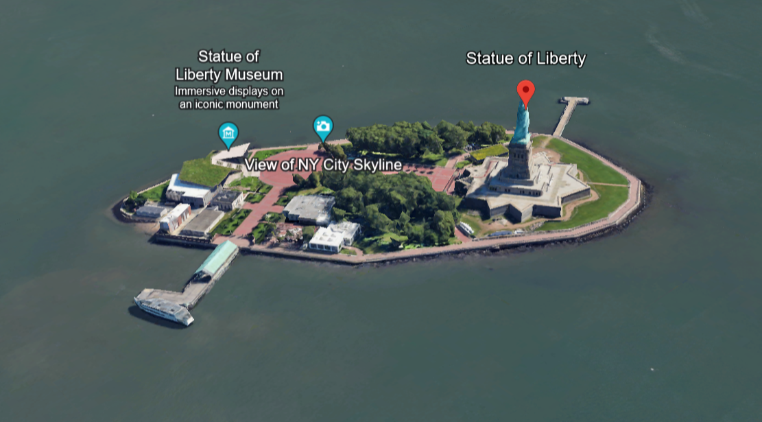
State maps are peppered with iconic landmarks and attractions that define the identity of each state. Whether it’s the Statue of Liberty in New York, the Grand Canyon in Arizona, or the French Quarter in Louisiana, these landmarks serve as beacons of history, culture, and pride.
Delving into the history of each state unveils a tapestry of stories and events that have shaped its identity. State maps offer a glimpse into the past, from the colonial settlements of the East Coast to the Wild West frontier of the Midwest and the Civil Rights landmarks of the South.
America’s cultural diversity is reflected in its state maps, with each state boasting its own unique blend of traditions, cuisine, and heritage. Whether it’s the cowboy culture of Texas, the Cajun cuisine of Louisiana, or the Native American heritage of New Mexico, state maps are a window into the rich tapestry of American culture.
State maps not only delineate borders but also serve as a connective thread between communities, cultures, and landscapes. They highlight transportation networks, interstate highways, and scenic byways that crisscross the country, fostering connections and facilitating travel between states.
Tourist Spots
Creating a comprehensive table of tourist spots on the entire American map is a monumental task due to the sheer number of attractions spread across the country. However, I can provide a simplified example focusing on some iconic tourist destinations in different regions of the United States:
| Region | Tourist Spots |
|---|---|
| Northeast | Statue of Liberty (New York), Niagara Falls (New York), Freedom Trail (Boston), National Mall (Washington, D.C.) |
| Midwest | Navy Pier (Chicago), Gateway Arch (St. Louis), Mount Rushmore (South Dakota), Mall of America (Minnesota) |
| South | Walt Disney World (Florida), French Quarter (New Orleans), Great Smoky Mountains (Tennessee/North Carolina), Savannah Historic District (Georgia) |
| West | Grand Canyon (Arizona), Yellowstone National Park (Wyoming/Montana/Idaho), Hollywood Walk of Fame (Los Angeles), Golden Gate Bridge (San Francisco) |
This table provides a glimpse of some popular tourist destinations across different regions of the United States. Keep in mind that America offers countless more attractions, and this table is by no means exhaustive.


FAQs
What are the different types of maps used in the United States?
There are several types of maps used in the United States, including political maps, physical maps, road maps, topographic maps, thematic maps (such as population density or climate maps), and more.
Where can I find detailed maps of U.S. states and cities?
Detailed maps of U.S. states and cities are available from various sources, including online mapping services like Google Maps, official state and city websites, as well as printed atlases and maps available at bookstores and tourist centers.
How accurate are online mapping services like Google Maps for navigation in the United States?
Online mapping services like Google Maps are generally very accurate for navigation in the United States. However, users should always exercise caution and be aware of potential inaccuracies, especially in rural or remote areas where mapping data may be less reliable.
What is the difference between a physical map and a political map of the United States?
A physical map of the United States shows the natural features of the landscape, such as mountains, rivers, and lakes, while a political map shows the boundaries of states, cities, counties, and other political divisions.
Conclusion
- Maps play a crucial role in understanding the geography, history, and culture of the United States.
- Various types of maps, including political, physical, road, topographic, and thematic maps, offer different perspectives on the American landscape.
- Online mapping services like Google Maps provide easy access to detailed and accurate navigation tools.
- Specialized maps cater to specific interests such as hiking, outdoor activities, and historical research.
- Historical maps offer insights into the evolution of the American landscape over time and can be accessed through digital archives and libraries.
- Interactive maps serve as valuable educational tools for exploring aspects of American history, culture, and demographics.
- Whether used for navigation, research, education, or recreation, American maps continue to be indispensable resources for understanding the diverse and dynamic nature of the United States.