


Google Earth is a program that provides a 3D representation of the Earth with the help of satellite imagery. Google Earth is a powerful tool, it helps us to experience the world in ways that seemed impossible before.
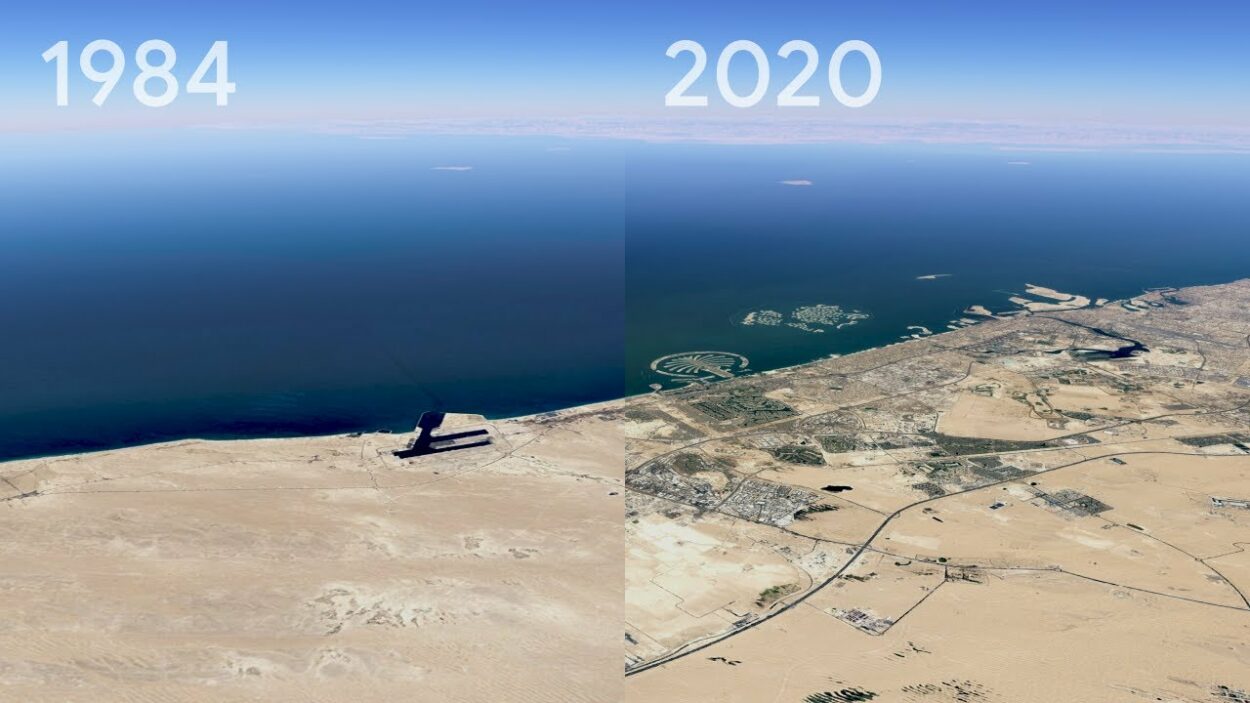
You can also go back more than forty years on Google Earth, to explore all those different periods, Google Earth can help you give that experience. If you want to make the time range either earlier or later, you are supposed to drag the time slider to the right or left.
Google Earth is a huge program and has several sources of data, which includes satellite imagery, aerial photography, and several other kinds of data. Nevertheless, Satellite imagery is considered the prime source of data.
Furthermore, Google Earth is such a cool program as it lets you explore the world and can also make planning a trip much easier.
If you want to know other cool facts about Google Earth, I say you keep on reading.
How Do I Go Back 20 Years On Google Earth?
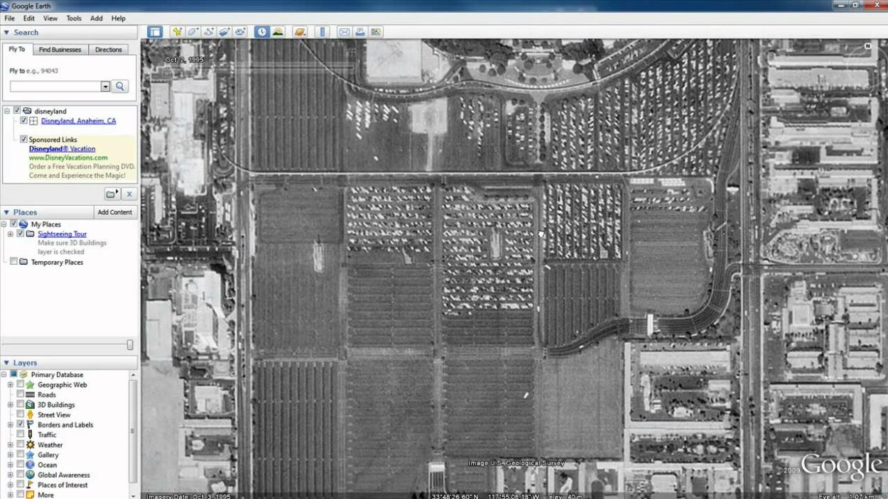
In order to go back in time on Google Earth, you have to open Google Earth Pro, where you you’ll find the search bar in the left panel. All you have to do is enter the specific location, and the app will take you to the place, in addition you’ll find clock icon in the top toolbar, that reads “Show Historical Imagery”, which will take you back in time.
Check out this video to learn how you can travel in time on Google Earth:
Google Earth is a vast program, it uses satellite imagery from different sources, like the Landsat program, which is a collaboration between the US Geological Survey and NASA.
Furthermore, Google Earth also obtains geological and topographic data from different sources, in order to fabricate a far more accurate and complete representation of the earth’s surface.
Users can easily explore the world by just entering the addresses and coordinates. In fact, in 2019, Google disclosed that Google Earth covers about 97 percent of the globe, which didn’t sit right with many countries.
Fun fact, Google Earth has been viewed as danger to privacy and national security, which led to it being banned in a number of countries. Moreover, several countries has also demanded to leave certain areas obscured in the satellite images, those areas are usually military facilities.
How Old Are Google Earth Images?
Google Earth displays the the planet by using a single image from a distance, however, after you zoom in the imagery turns into an imagery of the specific area, but with much finer details, that can also change in time and date.
Nevertheless, how old are those images? Well the Google Earth images can be anywhere from 1 to 3 years old.
Now, Google Earth obtains its imagery from either satellites or aircraft, although before the launch of NASA and the satellite called USGS’sLandsat 8, Google was relying on the imagery from Landsat 7, which went through a hardware malfunction, that resulted in diagonal gaps in the images.
Furthermore, if you want to check the age of an image, here’re few methods you can try:
- “Historical Imagery” feature: In order to use this feature, all you have to do is right-click on the location in question and choose ‘Historical Imagery’ from the menu, which will open a timeline on the top of the screen, that will show the available images for the specific location. You will then slide the timeline to right and left as to see the different available images, as for the date, you’ll see the them displayed on the bottom of the screen.
- Check metadata: Another method that you can use to check how old an image is by checking the metadata for the image. You merely have to right-click on the location and click on “Properties” from the menu, where you will see the information about the image, which will include the date of the image that it was captured on.
With the help of these methods, you will get to know when an image was captured and whether there are any newer images available or not. Although, you should keep in mind that the availability of those historical imagery as well as all the other sources of information can change depending on the location and where the image is sourced from.
Google Earth retains its data from several sources, and the images can change depending on two factors: location and the source of the imagery. While some imagery may be of high quality and newer, others may be outdated and may even be of low quality.
Google Earth is using a number of sources for its imagery and maps which include satellite imagery, aerial photography, and user-generated content.
| Source of Imagery | How Often Updated | Limitations |
| Satellite Imagery | Variable | The resolution can be lower than other sources |
| Aerial Photography | Variable | It may not be available for all locations |
How To Go Back In Time On Google Earth Android?

Google Earth is available on all device, be it Android or Apple. You can access Google Earth from a every device as long as it has a screen.
Mind you, Google Earth might slightly look different on each of these device, however that certainly doesn’t mean that it won’t perform the same way.
You can as easily go back in time on Google Earth Android as any other device. All you have to do is:
- Open Google Earth.
- Find a location.
- Click ‘View Historical Imagery’ or, above the 3D viewer, click Time.
FAQs
What Is Google Earth?
Google Earth is a software that allows you to explore as well as interact with a virtual globe and a detailed map of the Earth. It was developed by Google and is available on all the devices including Android and iOS.
Moreover, Google Earth was developed in 2001, but has been evolved with time, now it uses a bunch of sources for its data. For instance, it uses satellite imagery and aerial photography for a far more detailed images.
Why Are Some Images in Google Earth More Up-to-date As Compared To Others?
The quality of the imagery on Google Earth depends on the location and the source of the imagery, for instance if the image is obtained from the satellite and is captured years ago, it may not be of high resolution.
However, as for the newer images, they may be of high resolution as Google Earth now uses different and more developed sources.
You can see how old an image is by using ‘Historical Imagery” feature or by checking the metadata.
Can You Travel Back In Time On Google Earth?
Yes, you can travel back more than forty years on Google Earth. You merely have to open Google Earth and enter the location in the search bar that you can find on the left panel.
You will then be taken to the location, as you get there, find the Clock icon that reads ‘Historical Imagery’, which will take you back in time.
Conclusion
- Google Earth is one of the most developed software that grants its users the ability to view the globe in 3D. They’re a bunch of cool features, but the most fun feature is that you can go back in time.
- Google Earth can go back more than forty years, which will allow you to see how the world was and how it evolved.
- You can check the date of an image by just using the “Historical Imagery” feature or by checking the metadata.
- Google Earth uses several sources for its data, in fact it uses more than 2 sources for its images, which may vary in quality depending on the location and the source.
- Google Earth is available on all the devices and works the same way, you can just as easily use it on your mobile as you use it in your laptop.
Other Articles
- How Do You Get a Live View on Google Earth? [Step-by-Step Guide]
- How Can You Tell if Google Earth Is Up-to-date?[Answered]
- Can You Tell When a Google Earth Picture Was Taken? [Find Out]