
Google Earth is a program that gives its users a 3D representation, it’s a highly developed software that can be used for many purposes, for instance, you can create, store, view, and interact with data as it relates to location. In addition, it can also be useful for students as it allows teachers the ability to present visual and written material to convey concepts and ideas.
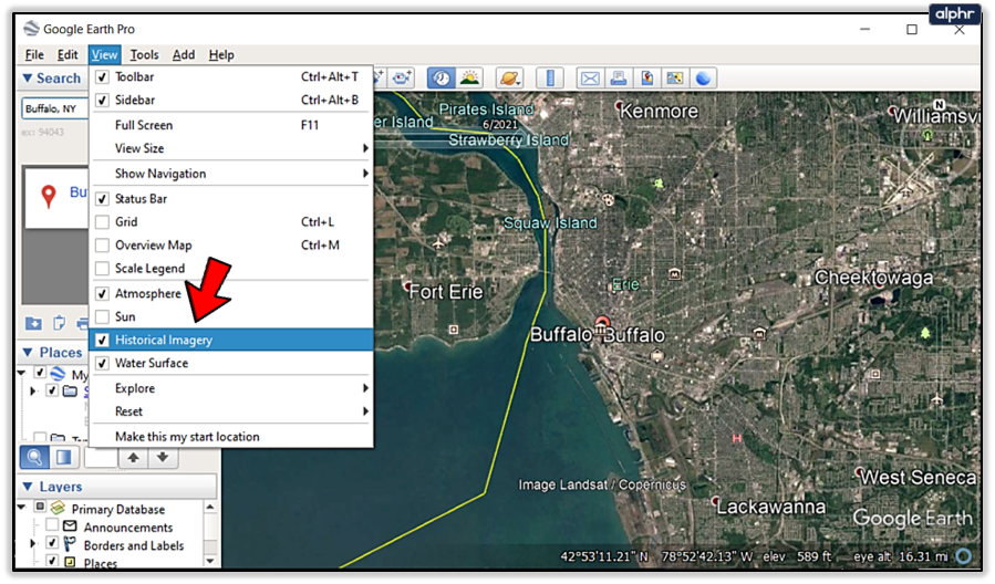
Google Earth isn’t like any other software, it can do things that most of these programs couldn’t do, for instance, you can change the year on Google Earth, by clicking View and then clicking “Historical Imagery”, where you’ll locate the clock icon, click it and choose the time period you want to travel to.
Google Earth is now available for all devices, whether it’s iOS or Android. Furthermore, Google Earth works the same way on all of these devices, so changing the years on Android is as easy as it’s on a Desktop.
Keep reading…
Can You Go Back 10 Years On Google Earth?
Google Earth was launched in 2001, it has been using several kinds of sources for its data. Today, Google Earth has an immense amount of data, which is available to its users. And those data can help you travel back more than 10 years on Google Earth.
Google Earth sources its data from several sources with includes Satellites, the satellite and aerial images you see on Google Earth are taken by cameras on satellites and aircraft, which collect each image at a specific date and time.
Check out this table to learn about the different sources that Google Earth uses:
| Sources Of Data | Features |
| Satellite Imagery | Satellite Imagery provides the most detailed images. Google Earth has been using it for quite some time with the highest resolution, but recent images may not be available |
| Aerial Photography | Aerial Photography images are of good quality, these images are taken from airplanes and aircraft like drones and other flying vehicles. |
| Topographic Data | Topography data can be obtained from USGS The National Map US Topo site, this kind of data is referred to the information about the elevation of the earth’s surface which includes roads, streams, railroads, towns, etc. |
| Land Use Data | Land Use is also known as Land Cover data, it refers to the information that is a result of turning the raw satellite data into “land use and land cover” (lulc) categories, which are established on the return value of satellite imagery. Moreover, Land Use data includes areas like agriculture, forestry, or urban development. |
| Geological Data | The Geological Data in Google Earth can benefit geologists as it can be used to pinpoint geological features and map out the location of deposits of minerals as well as other resources. |
| Other data | Google Earth encompasses data about transportation networks, weather patterns, and other features. |

Google Earth came out in 2001, however, it isn’t the same, it has evolved immensely and released so many different features that made people’s life easier.
- Google Earth has many sources for the imagery data, the detailed satellite imagery and aerial photography allow users to explore the globe from above which may help you get a sense of the layout as well as the geography of places.
- Google Earth has a feature called ‘Historical Imagery”, which basically allows its users to see older images taken from satellite locations, these images may date back more than 20 years.
- Google Earth has another interesting feature called “Measure Distance and Area”. This feature allows the user to measure and map out a plan. It can be useful for measuring the size of a property, planning a trip, or even calculating the distance between points.
- Google Earth also renders its users to make and even share custom maps and placemarks. This feature can be useful for marking locations of interest or highlighting specific areas.
- Last but certainly not least, Google Earth includes a feature that suggests locations and points, which are of interest to its users, these suggestions are primarily based on users’ past searches and interactions with the app.
How Does Google Earth Work On Android?
Google Earth is a huge program and is available for all devices, but we’ll talk about how it works on Android. When you open the app, you see a 3D globe presenting the surface of the Earth, you can zoom in and drag to move around the Earth, or you can just use the navigation controls on the side of the screen.
Google Earth has been using sources like satellite imagery and aerial photography for detailed images of the Earth’s surface, while the older images may be of high resolution, recent images may even not be available.
Furthermore, Google Earth can be explored in 3D as well as 2D dimensions, this way you’ll get a better sense of the Earth’s surface. In addition, Google Earth has several features that render its users the ability to interact and explore the map in many different ways. For instance, you may search locations, coordinates, or addresses and view them on the map, you also measure distances and areas with the help of its feature called “Measure Distance and Area”.
All and all, we can say that Google Earth rocks! It not only provides an immersive and interactive experience to the user, but it can also be useful for many purposes like Education, research, planning a trip, or simply learning as well as exploring the world.
Check out this video to see how you can make use of Google Earth on Android:
FAQs
How Can I Download Google Earth On Android?
Google Earth can be downloaded from the app store on Android, it’s as easy to use on Android devices as it’s on Desktop or iOS.
Google Earth is free software that can only be downloaded from the app stores, however, you can also use the browser version for quick access.
How Do You Go Back In Time On Google Earth On Android?
Using Google Earth may seem difficult at first, but when you start to play with it and explore and use its features, it becomes rather easy to access any feature.
So to go back in time on Android, all you have to do is click View and then select “Historical Imagery”, there you’ll see the clock icon, click on it, and choose the time period you wish to travel to.
Where Does Google Earth Get Its Data?
Google Earth is a huge program created by Google, it uses many sources for its data which includes satellite imagery, aerial photography, Topographic data, Land Use data, as well as others.
Google Earth uses different kinds of sources to get accurate data, whereas, it may not be updated every minute, which is the only downside of Google Earth.
Conclusion
- Google Earth gives its users an immersive and interactive experience, there’re so many different kinds of features that can be useful for many purposes.
- Google Earth is available for every device, you can download it from the app store, or just use the browser version, which works the same way.
- You can just as easily change the time on Google Earth Android as on any other device, you merely have to click view, click historical imagery, and find the clock icon.
- Google Earth has been using different kinds of sources for the data for many years, it provides a feature that allows you to travel back in time, you can go back more than 40 years and explore the world.
- Google Earth provides many other features that can be useful, for instance, the “Measure Distance and Area” feature lets you measure and map out a plan.
- Google Earth works the same way and provides similar features on all devices, you can do all the things on iOS that you would do on Android or Desktop.
Other Articles
- How Do I Go to a Specific Place on Google Earth?[Explore]
- Can You Tell When a Google Earth Picture Was Taken? [Find Out]
- How Do You Get a Live View on Google Earth? [Step-by-Step Guide]