![How Often Does Google Earth Get Updated?[Truth]](https://gearthhacks.com/wp-content/uploads/2023/01/images-7-1.jpg)
![How Often Does Google Earth Get Updated?[Truth]](https://gearthhacks.com/wp-content/uploads/2023/01/images-7-1.jpg.webp)
Google Earth is a powerful tool that allows users to explore and visualize the world from the comfort of their own computers. With its satellite imagery, aerial photography, and user-generated content, Google Earth offers a detailed and up-to-date view of the world.
But how often does Google Earth get updated? The frequency of updates can vary depending on the capabilities of the satellite and aerial photography equipment, as well as the demands of the users.
In this blog post, we’ll explore the various sources of imagery and maps that Google Earth uses, the factors that affect the frequency of updates, and how to check for updates in the program.
Sources of Imagery and Maps
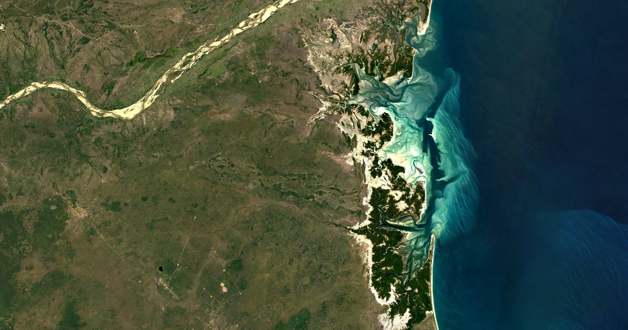

Google Earth uses a variety of sources for its imagery and maps, including satellite imagery, aerial photography, and user-generated content. Satellite imagery is collected by a network of satellites orbiting the Earth, which take high-resolution photos of the surface from above.
These images are then processed and assembled into a mosaic, which provides a detailed view of the Earth’s surface. Google Earth uses satellite imagery from a number of different satellite operators, including NASA, the European Space Agency, and commercial companies such as DigitalGlobe.
Aerial photography is another source of imagery for Google Earth. This type of imagery is collected by planes or drones flying over the Earth’s surface and taking photos from above. Aerial photography can provide higher-resolution images than satellite imagery, but it’s typically more expensive and may not cover as large an area.
User-generated content is another important source of imagery and maps for Google Earth. This includes content such as photos, videos, and 3D models created by users and shared through Google’s Street View and SketchUp programs. User-generated content can provide a more local and personal perspective on the world and can help fill in gaps in satellite and aerial imagery.
By using these different sources of imagery and maps, Google Earth is able to provide a detailed and up-to-date view of the world. However, the frequency of updates and the quality of the imagery can vary depending on the source and the specific location.
Factors That Affect Update Frequency
| Factor | Description |
| Availability of new imagery and maps | The availability of new satellite imagery, aerial photography, and user-generated content can affect the frequency of updates |
| Capabilities of satellite and aerial photography equipment | The resolution and coverage of satellite and aerial photography equipment can influence the frequency of updates |
| Demand for updated content | Demand for updated imagery and maps in certain locations can affect the frequency of updates |
| Automatic updates | Enabling automatic updates can help ensure that you have the latest version of Google Earth |
There are a number of factors that can affect the frequency of updates to Google Earth, including the availability of new imagery and maps, the capabilities of satellite and aerial photography equipment, and the demand for updated content.
One of the main factors that determine how often Google Earth gets updated is the availability of new imagery and maps. Google Earth uses a variety of sources for its imagery, including satellite imagery, aerial photography, and user-generated content.
The frequency of updates to these sources can vary depending on the capabilities of the satellite and aerial photography equipment, as well as the demands of the users. For example, satellites may be able to capture new images more frequently in some areas than in others, depending on their orbit and the resolution of their cameras.
Similarly, aerial photography may be more frequently updated in certain areas due to higher demand or better access. Another factor that can affect the update frequency of Google Earth is the demand for updated content.
In general, areas with higher demand for updated imagery and maps are likely to be updated more frequently than areas with lower demand. For example, urban areas with rapid development or tourist destinations may be updated more frequently than rural or remote areas.
Manually Updating Google Earth


To manually update Google Earth, you’ll need to download and install the latest version of the program. Here are the steps to follow:
- Visit the Google Earth website and click on the “Download” button.
- Select the version of Google Earth that you want to download. There are versions available for Windows, Mac, and Linux.
- Follow the prompts to download and install the program. You may need to close any open programs or windows and restart your computer before the installation can be completed.
- Once the installation is finished, open Google Earth to check that it’s running the latest version. You can check the version number by going to the “Help” menu and selecting “About Google Earth.”
By following these steps, you can manually update Google Earth to the latest version. It’s important to keep your version of Google Earth up to date in order to get the most out of the program and ensure that you have access to the latest features and data.
Tips for Keeping Google Earth Up to Date
There are a few simple tips that you can follow to keep your version of Google Earth up to date:
- Enable automatic updates: Most versions of Google Earth include an option to enable automatic updates, which will automatically download and install the latest version of the program whenever it’s available. To enable automatic updates, go to the “Tools” menu and select “Options.” Mark the box beside “Automatically check for updates” under the “General” option.
- Check for updates regularly: Even if you’ve automatic updates enabled, it’s a good idea to check for updates manually from time to time. Go to the “Help” menu and choose “Check for Changes” to see if there are any updates. This will open the Google Earth update window, which will show you if there are any updates available and give you the option to install them.
- Keep your computer up to date: Updating Google Earth is not the only thing you need to do to keep your version of the program up to date. You should also make sure that your computer is running the latest version of its operating system and has the latest updates and patches installed. This will help ensure that Google Earth runs smoothly and is compatible with your computer.
How to Check for Updates on Google Earth?

To check for updates in Google Earth, you can use the “Historical Imagery” feature or check the metadata for an image. Here’s how:
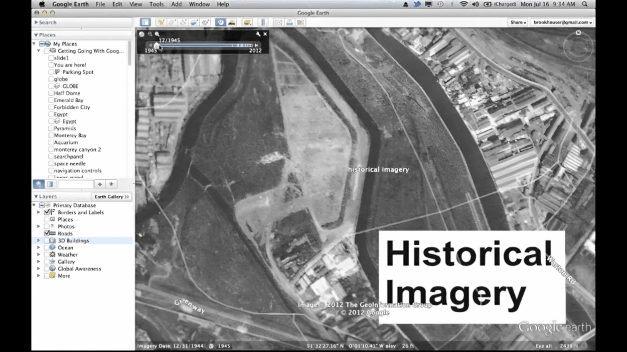
Historical Imagery Feature
To use this feature, right-click on the location in question and select “Historical Imagery” from the context menu. A timeline will appear at the top of the screen, showing the available images for the location.
You can then slide the timeline to the left or right to view the different images, and the date of each image will be displayed at the bottom of the screen. If there are newer images available, they will be shown at the right end of the timeline.
Check Metadata
Another way to check for updates is to check the metadata for an image. To do this, right-click on the location and select “Properties” from the context menu. This will open the “Properties” window, which will show you information about the image, including the date it was captured.
If there’s newer imagery available, it’ll not be reflected in the metadata.
By using these methods, you can get an idea of when an image was captured and whether there are newer images available. However, it’s important to note that the availability of historical imagery and other sources of information may vary depending on the location and the source of the image.
FAQs
How Do I Know if My Version of Google Earth Is Up to Date?
To check if your version of Google Earth is up to date, you can use the “Historical Imagery” feature or check the metadata for an image.
Alternatively, you can go to the “Help” menu and select “Check for Updates” to see if there are any updates available for your version of the program.
Can I Set Google Earth to Update Automatically?
Most versions of Google Earth include an option to enable automatic updates, which will automatically download and install the latest version of the program whenever it’s available.
To enable automatic updates, go to the “Tools” menu and select “Options”. In the “General” tab, check the box next to “Automatically check for updates”.
Why Are Some Images in Google Earth More Up-to-date Than Others?
The quality and currency of the imagery in Google Earth may vary depending on the source and the specific location. Some images may be more current than others, while others may be outdated or of low quality.
The “Historical Imagery” feature can be useful for viewing previous versions of the imagery and maps for a particular location and getting an idea of when an image was captured.
Can I Request Updates for Specific Locations in Google Earth?
If you would like to request updates for specific locations in Google Earth, you can use the “Report a Problem” feature. To access this feature, go to the “Help” menu and select “Report a Problem”. This will open a form where you can enter your request and submit it to Google.
Please note that it may not be possible to fulfill all requests for updates, and the availability of updates may vary depending on the location and the source of the imagery.
Conclusion
- Google Earth is a powerful tool that allows users to explore and visualize the world from the comfort of their own computers.
- Google Earth gets updated by the availability of new imagery and maps. Google Earth uses a variety of sources for its imagery, including satellite imagery, aerial photography, and user-generated content.
- The frequency of updates can vary depending on the capabilities of the satellite and aerial photography equipment, as well as the demands of the users.
- To check for updates in Google Earth, you can use the “Historical Imagery” feature or check the metadata for an image.
- You can open Google Earth to check that it’s running the latest version. You can check the version number by going to the “Help” menu and selecting “About Google Earth.”
Related Articles
- Google Earth – Is it a True GIS? [The Truth]
- How did Google Create Google Earth? (History Tour)
- Why Google Earth is so Out-Dated? [Answered]