![What Is the Date of Google Earth Images?[Explained]](https://gearthhacks.com/wp-content/uploads/2022/12/google_earth_banner-1.jpg)
![What Is the Date of Google Earth Images?[Explained]](https://gearthhacks.com/wp-content/uploads/2022/12/google_earth_banner-1.jpg.webp)
Hello everyone! If you’re anything like us, you love exploring new places and discovering new things. Whether you’re a travel enthusiast, a geography buff, or just someone who loves to learn, there’s no better tool for discovering the world than Google Earth.
But have you ever stopped to think about when the images on Google Earth were last updated? Whether you’re using it to plan a trip, research a new location, or just explore the world, it’s important to have the most up-to-date information possible.
That’s why we’re here today to answer the question: What is the date of Google Earth images? We’ll dive into the details of how Google Earth images are captured, how they’re updated, and what limitations they have. So strap in and let’s take a closer look at one of the coolest tools on the web.
The Importance of Up-to-date Images

So, why is it important to have up-to-date images on Google Earth? Well, there are a few important causes.
First and foremost, up-to-date images are critical for navigation and planning. Whether you’re a traveler looking to explore a new city or a hiker planning a trek in the great outdoors, having the most recent images can make all the difference. It can help you avoid road closures, detours, and other obstacles that might otherwise derail your plans.
Second, up-to-date images are essential for research and analysis. Whether you’re a scientist studying a particular ecosystem, a geographer mapping changes to the earth’s surface, or an archaeologist exploring ancient ruins, having the most recent images can help you make new discoveries and draw meaningful conclusions.
| Location | Date of Latest Image |
| New York City | 2022 |
| Paris | 2021 |
| London | 2020 |
And finally, up-to-date images are crucial for businesses and decision-making. Whether you’re a real estate developer scoping out potential sites, an investor considering a new venture, or just someone who wants to get a better sense of a particular location, up-to-date images can give you a competitive edge and help you make better decisions.
How Are Google Earth Images Captured?

Have you ever wondered how Google Earth captures its images? Well, wonder no more, because we’re about to spill the beans!
The first step in capturing Google Earth images is to gather data from a variety of sources. This includes satellite imagery, aerial photography, and street-level imagery captured by special vehicles equipped with cameras and sensors.
Once this data is collected, it’s stitched together to create a seamless, high-resolution map of the earth’s surface. Google uses advanced algorithms to process this data and remove clouds, haze, and other obstructions that might otherwise block our view of the earth.
Of course, taking pictures is just the beginning. To ensure that Google Earth users have the most up-to-date information possible, Google must constantly update its images. This is done by revisiting key locations on a regular basis and capturing new images to replace the old ones.
So, there you have it! That’s how Google Earth captures its images. Who knew that capturing a picture of the entire planet could be such a complex process?
Updating the Images on Google Earth
Now that we’ve covered how Google Earth images are captured, let’s take a closer look at how they’re updated. After all, what good is having a high-resolution map of the earth if the information is out of date?
The process of updating Google Earth images is a continuous one. Google is constantly revisiting key locations and capturing new images to replace the old ones. This allows them to provide users with the most up-to-date information possible.
But how does Google determine which locations to revisit and when? That’s where things start to become a bit trickier, though. In order to prioritize locations for the update, Google takes into account a variety of factors, including population density, economic activity, and environmental changes.
For example, Google might prioritize updating images of a city that has recently undergone rapid development or a region that has been impacted by a natural disaster. On the other hand, images of remote, sparsely populated areas might not be updated as frequently.
It’s worth noting that while Google strives to provide the most up-to-date images possible, there are limitations to what they can do. For example, weather conditions, cloud cover, and other obstructions can sometimes prevent Google from capturing clear images.
But despite these limitations, Google remains committed to providing users with the most up-to-date images and information possible. So, the next time you’re exploring the world on Google Earth, know that you’re getting a glimpse of our planet as it’s right now – and that’s pretty amazing!
The Limitations of Google Earth Images
While Google Earth provides us with a wealth of information about our planet, it’s important to understand that there are limitations to what its images can show us.
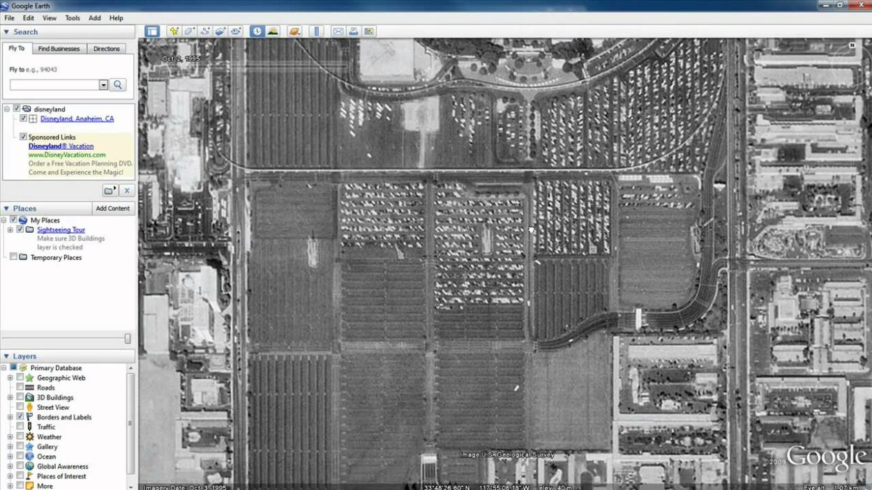
For starters, Google Earth images are often several months or even years old. While Google does its best to provide the most up-to-date images possible, it’s not always possible to capture new images of every location on the planet in real-time.
Another limitation of Google Earth images is the resolution. While the images are high-resolution, they can still only provide us with a bird’s-eye view of the earth’s surface. This means that some details, such as individual buildings or small features, might not be visible.
In addition, Google Earth images can be affected by weather conditions, such as cloud cover or haze, which can make it difficult to see what’s happening on the ground. And in some cases, entire regions might not be covered by Google Earth images, either because the images are not available or because the images are too old to be of any use.
It’s also worth noting that Google Earth images can be subject to censorship by governments or other organizations. In some countries, certain locations might be blocked or obscured for security reasons.
So, while Google Earth provides us with a wealth of information about our planet, it’s important to understand its limitations and use other sources of information when necessary. With that in mind, we can still enjoy exploring the world on Google Earth and discovering all the amazing things it has to offer!
How to Use Google Earth for Research and Exploration?
Google Earth can be a valuable tool for researchers, explorers, and anyone interested in learning more about our planet. Here are some tips for using Google Earth to its fullest potential:
Use the Historical Imagery Feature
Google Earth allows you to view images of a location from different time periods. This can be useful for:
- Seeing how a location has changed over time
- Comparing current images to historical ones
Explore Different Layers
Google Earth has a variety of layers you can add to your map, including:
- Satellite imagery
- Street maps
- Information about landmarks and attractions
Take advantage of these layers to get a better understanding of a location.
Use the Measurement Tools
Google Earth has a variety of measurement tools, including a ruler and a path measurement tool, that you can use to measure:
- Distances
- Areas
- Heights
Take a Virtual Tour
Google Earth has a feature called “Voyager” that allows you to take virtual tours of different locations around the world.
This can be a great way to explore new places without leaving your home.
Use Google Earth for Planning
Whether you’re planning a trip or just exploring, Google Earth can be a useful tool for getting a better understanding of a location.
You can use the street view feature to get a sense of what a location looks like, or you can use the measurement tools to plan a hike or other outdoor adventure.
FAQs
How Often Are the Images on Google Earth Updated?
The frequency of updates to the images on Google Earth varies depending on the location and availability of new satellite imagery.
In general, urban areas are updated more frequently than rural areas.
Can I Submit a Request for a Specific Area to Be Updated on Google Earth?
Unfortunately, there’s no way for individual users to request updates to specific areas on Google Earth.
The company prioritizes updates based on a variety of factors, including the availability of new satellite imagery and the importance of the location.
Conclusion
- The conclusion of this blog post highlights the significance of up-to-date images on Google Earth and the role they play in providing accurate information to its users.
- Up-to-date images are critical for navigation and planning. Whether you’re a traveler looking to explore a new city or a hiker planning a trek in the great outdoors.
- Google Earth images gather data from a variety of sources. This includes satellite imagery, aerial photography, and street-level imagery captured by special vehicles equipped with cameras and sensors.
- Google Earth images are often several months or even years old. While Google does its best to provide the most up-to-date images possible, it’s not always possible to capture new images of every location on the planet in real-time.
- In conclusion, Google Earth provides a valuable tool for those who rely on geographical information and its constantly updating images ensure the provision of the most accurate information possible.
Related Articles
- Where Is the Time Slider on Google Earth?[Answered]
- How Do You Go Back in Time on Google Earth?[Guide]
- How Do You Go Back in Time on Google Earth Mobile? [Step-by-Step Guide]